

A War of Deep Intel
Today, we’ll discuss a key angle to the ongoing war with Iran. Indeed, what I‘m about to explain goes right to the heart of how the conflict is unfolding.
But first, let’s time-travel back to Monday morning, December 8, 1941, a damp, chilly day in Washington, D.C. For what it’s worth, the weather was overcast, with light rain and temperatures in the mid-30s (F).
Later on, President Franklin Roosevelt was scheduled to address a Joint Session of Congress, to request a declaration of war against the Empire of Japan after its sneak attack on American forces the day before at Pearl Harbor, Hawaii. Indeed, a vast chapter of history began to unfold.
Meanwhile, another critical matter also played out in the capitol city but with far less visibility. That is, on the same December morning, a group of Navy and Army officers walked up to the headquarters of the National Geographic Society on 16th Street, just north of the White House.

Headquarters of National Geographic Society, 1930s. Courtesy NGS.
A custodian unlocked the front doors to the building. The officers entered and requested an audience with the president of the organization, Gilbert H. Grosvenor (1875 -1966), whose career spanned much of the existence of that institution. More specifically, since the 1920s Grosvenor had grown the National Geographic Society from its clubby roots as a hangout for quirky world travelers into a well-regarded research and publishing institution focused on geography, archaeology and related earth and cultural sciences.
With deference and great courtesy, Grosvenor received his unexpected guests and asked what he could do for them.
The senior officer replied, “Sir, on behalf of the President of the United States, we would like to know if the National Geographic Society has maps of Japan that it will make available to the Navy and Army for this upcoming war.”
Very unsubtly, the question hinted at major operational-strategic weaknesses within the country’s military structure, namely that America’s Navy and Army lacked proper maps.
And it was not just maps of Japan that the military lacked. The Navy and Army lacked detailed, up-to-date maps of Korea, China, Indochina, most Pacific Islands, India and Australia. And we may as well add to the list that the U.S. armed forces required updated maps of Greenland, Iceland, Europe, the Soviet Union, North Africa, the rest of Africa, the Middle East and South America.
In short, as America entered World War II, its War and Navy Departments (each was a separate cabinet office back then) lacked essential basics of what’s called “expeditionary warfare,” namely good maps of overseas landscapes where ships would sail and troops would fight.
As you can surmise, America was fortunate that a private entity – the National Geographic Society – had deep archives of maps from across the world, which now brings us to the present, where we can dig in…
War Is Intel
It’s been four weeks since Israel-U.S. launched a war against Iran, and the news flow is “all over the map,” if you’ll excuse an old saying in the context of how I began this note. That is, we have plenty of opinions from all over, but actual facts are harder to come by, which is the nature of tactical and operational secrecy during wartime.
According to U.S. Central Command (CENTCOM), American forces have so far struck nearly 10,000 targets in Iran with a mix of missiles, standoff weapons, close-in guided munitions like JDAM, and even old-fashioned gravity bombs now that Iranian air defenses have been suppressed or destroyed. And apparently, if imagery of B-1s and B-52s are any indication, our side is blowing the bejeezus out of the other.
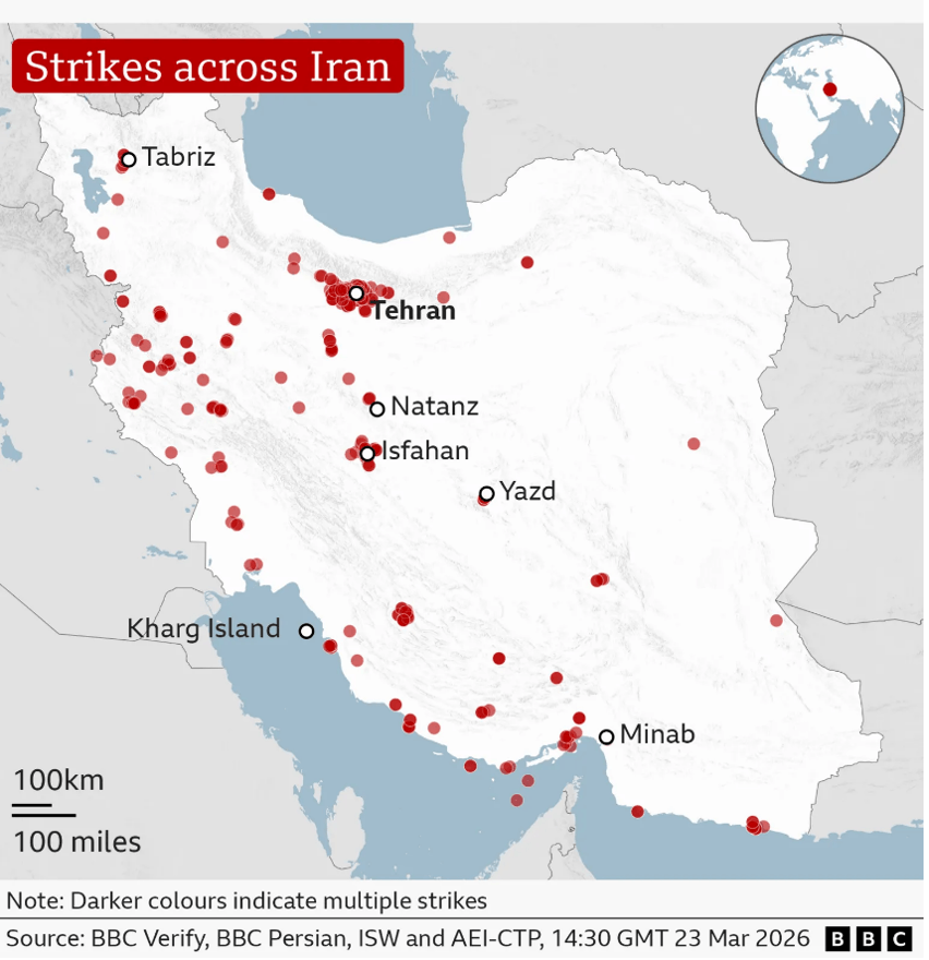
U.S./Israel air strikes in Iran. Courtesy BBC.
On the other end of conflict, Iran has fired back with barrages of many thousands of missiles and drones, although that nation’s attacks are distinctly fewer over time.
Iran has targeted Israel, of course, as well as U.S. positions and bases across the Middle East. And Iran has also targeted many industrial and civilian targets in Arab nations that range from Jordan to Oman, and countries in between.
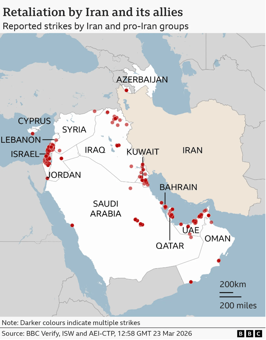
Iran attacks on U.S./Israel targets, and other Gulf nations. Courtesy BBC.
At this stage, what do we know? Well, if there’s one thing that all these air and missile strikes have in common, it’s some level of intelligence on the intended target sets. That is, attacks are based on an extensive program of intel-gathering that, over time, has compiled maps, grid coordinates, latitudes & longitudes, GPS guidance, AI-assisted targeting, laser designation spots and more.
In this new era of warfare neither the U.S. nor Israel (nor Iran, to be clear) has a “National Geographic” issue like we saw above, from back in 1941. Anymore, there’s no need to knock on the door of a travel and geography magazine to beg for maps.
In fact, U.S. and Israeli forces have vast databases of what are called “geographic information systems” (GIS) comprised of layer upon stacked layer of information at all scales, from the biggest of big pictures down to the smallest, granular data.

GIS: Geographic Information Systems. Courtesy animalia-life.club.
Of course, everything begins with basic geography, with a “map” like you might see in a world atlas that you can buy at any bookstore. But now add extensive data on roads, down to the thickness of paving and weight restrictions on bridges. Or perhaps add data on power towers and pipelines, to include fuel supply channels, generation, transmission substations, pumping stations, interconnects, valves, chokepoints and much more.
Or you can find data on fixed military, industrial sites, scaling down to the location of critical nodes of control, power distribution, supply lockers, military-related equipment, and much more.
And there’s even data on who lives where, in what apartment building, on which floor, and which window opens into the bedroom or kitchen of that person: useful for drone operations in some instances.
On the other side of the fight, Iran has maps, too, and evidently very good intel. Clearly, Iranian missiles have target information and guidance systems that can drop warheads directly onto critical sites such as Israeli bases and industrial facilities, or other important venues across the wider Arab region.
In fact, it appears that some Iranian missile hits on so-called “civilian” areas in Tel Aviv, Haifa or Dimona were likely aimed straight at the homes of senior Israeli political, military or scientific and engineering cadre. While other Iranian drone hits on hotels across the Gulf region seem to have been carefully aimed at particular rooms where certain guests were staying, to include U.S. and European military and defense-support personnel.
One takeaway is that, when you see news of a bombing attack or missile strike, don’t just look at it as a single, isolated event. Because the explosion is simply the end product, the culminating, noisy “bang” after a long train of intelligence gathering which, in some cases, goes back many decades.
Collect and Archive
For example, when you see an account of an air strike on an Iranian cave full of missiles, consider the years-long chain of work that went into watching the other side dig those tunnels. Somebody watched the mounds of rock outside that came out, calculated the volume of excavation, and monitored equipment that went in. And someone likely used advanced techniques (which is all that I’ll say) to identify directions and depths of the tunnels.
Definitely, somebody archived all that information. It’s in massive computer storage sites around the country, wired with deep redundancy and extensive cross-references. If a commander needs to plan an attack mission, the information is right there at the fingertips. Indeed, we’re a long way from having to visit the National Geographic Society of old.
When the time comes to bomb any particular target, teams of intel analysts and ordnance experts select the right spot, down to pretty much the square meter. Also, as they sift through options, they choose the proper weapon in terms of size and weight, type of charge, fusing, guidance, and delivery platform.
Then, after choosing a target and assigning a weapon, it’s likely that two or three layers of command screen the overall mission to review the data behind the strike: What? Where? Why? In other words, what justifies the selected weapon, and the risk to whomever or whatever delivers the package? Indeed, nothing happens by accident, certainly not when it comes to delivering ordnance to a target.
Another way to say it is that we’re a long way from World War II, when in 1942 Jimmy Doolittle planned and executed his famous air raid on Tokyo by using National Geographic maps.
And we’ve certainly progressed from, say, the Vietnam War; from back when older models of the B-52 aircraft flew what were called “Arc Light” missions and dropped many dozens of unguided bombs across vast swaths of ground, with the idea to hit something and blow stuff up. It was impressive, but not necessarily effective.
Today, delivering ordnance is all about intel – and often, “deep” intel – that goes far behind the target.
Sure, many air strikes are opportunistic, in the sense that a drone sees something and a weapon quickly drops down. Then again, why was that drone is that particular area? Why did it carry certain ordnance? How did the drone operator and supervising commander have so much information at hand to make the decision to release? Again, it’s intel.
The point is, any air strike probably represents many years of watching-watching-watching and deep learning about the other side, via space and other forms of imagery, coupled with related intel gathering, from human spies to electronic signals. Then finally, when a war comes around, one foundational part of the job of policymakers and commanders is to assess the priority of long lists of target aimpoints, and to select the proper weapon.
Meanwhile, as you can probably imagine, the targeting process has become more and more automated. Indeed, most targets are screened through vast data banks of geographic and industrial intel based on decades of past collection and then scrubbed down to a specific point on (or below) the ground where some sort of device must land.
Here’s where a company like Palantir (PLTR) comes into play. It provides software and algorithms to help and expedite efforts while analysts screen mountains of data, both historical and current. Or as the saying goes, “Put warheads on foreheads.”
There’s much more to say, but that’s all for now. Again, the takeaway is to help you appreciate what’s behind the flashy, headline news, and understand the deep intel behind almost all of what’s happening out there.
And sooner or later, the Iran war will end. The side with better intel will be the winner.
Thank you for subscribing and reading.

Comments: